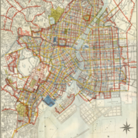
Tokyo Reconstruction Project Summary Map
Dublin Core
Title
Tokyo Reconstruction Project Summary Map
Description
Legend (from top to bottom)
- Reconstruction project land rezoning execution area districts (Number indicates district number) (◯ is state execution)
- Reconstruction project truck road (Red number indicates width in meters, blue number indicates number)
- Reconstruction project auxiliary road (same as above)
- Reconstruction plan truck road (only things cut off by the plan)
- Reconstruction plan auxiliary road (same as above)
- City planning project road
- City planning road (only things cut off by the plan)
- Current major road
- Reconstruction project waterways new excavation and repair (Number indicates width in meters)
- Reconstruction project waterway reclamation
- Current major rivers and waterways
- Reconstruction project newly established parks
- Current major parks - Reconstruction project central wholesale market (principal and auxiliary)
- Areas destroyed by fire
Type
Map
Identifier
198958
- Date Added
- March 30, 2017
- Collection
- Maps
- Citation
- “Tokyo Reconstruction Project Summary Map,” Imaging Kantō, accessed June 21, 2024, https://imagingkanto.trinity.duke.edu/items/show/23.
