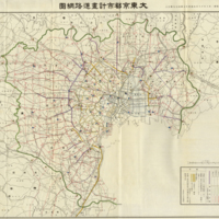
Greater Tokyo City Plan Road Network Map
Dublin Core
Title
Greater Tokyo City Plan Road Network Map
Planning Decision: August 18, 1927 Home Ministry Notice No. 409 Announcement project
Description
Table
Width (columns)
Construction execution period, From 1927 to 1936
Note
Width (columns)
- More than 11 m
- More than 15 m
- More than 22 m
- Plan route
- Established Plan
- National highway and considered routes
- Reconstruction plan route
Construction execution period, From 1927 to 1936
Note
- Yellow line indicates a pre-existing principle road
- Chain line indicates necessary connections outside the city planning area
- Under deliberation
- Construction completed locations
- Presently under construction
December 1929 to present Tokyo prefecture precinct construction execution completion period, 1931 Tokyo Prefecture
Engineering Department Survey
Engineering Department Survey
Type
Map
Identifier
198959
- Date Added
- March 30, 2017
- Collection
- Maps
- Citation
- “Greater Tokyo City Plan Road Network Map,” Imaging Kantō, accessed June 21, 2024, https://imagingkanto.trinity.duke.edu/items/show/24.
