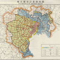
Tokyo City Plan Area Map
Dublin Core
Title
Tokyo City Plan Area Map
Description
Document Details
- January 6, 1925 Home Ministry Notice No. 14 Implemented February 15, 1025
- June 17, 1926 Home Ministry Notice No. 109 Implemented August 17, 1926
- September 14, 1926 Home Ministry Notice No. 133 Implemented September 14, 1926
- April 5, 1929 Home Ministry Notice No. 121 Implemented May 15, 1929
Legend (right to left)
- Tokyo City Plan Area Boundary
- City County Boundary
- Municipal Boundary
- Urban Construction Method Execution Area Boundary
- Former Urban Construction Method Coverage Area Boundary
- Rivers, Ponds, Waterways
- Road Network Routes
- Commercial Area
- Designates both sides of the roads along the construction routes that border construction sites in the commercial area - Residential area
- Industrial area
- First-class special district within the industrial area
- Second-class special district within the industrial area
- End of the designated portion
Type
Map
Identifier
198960
- Date Added
- March 30, 2017
- Collection
- Maps
- Citation
- “Tokyo City Plan Area Map,” Imaging Kantō, accessed June 21, 2024, https://imagingkanto.trinity.duke.edu/items/show/25.
